Portland’s Freeway Names, War Veterans Freeway

War Veterans Freeway (I-205): http://en.wikipedia.org/wiki/Interstate_205_(Oregon–Washington)

Back to Minnesota Freeway

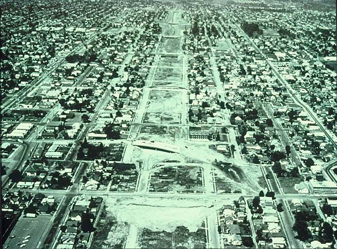
I-205, or “East Portland Freeway,” now officially named the “War Veterans Memorial Freeway” is Portland’s most controversial highway. The “Interstate 50th Anniversary” project has a really good write up of it’s history.

“This 26.6-mile-long route, which meets I-5 at Tualatin south of Portland, and then continues east through West Linn and Oregon City before heading north, was one of themost delayed and controversial of Oregon’s interstate segments. It was, perhaps not coincidently, one of the first of Oregon’s highways to follow successfully the requirementsof the National Environmental Policy Act of 1969 (NEPA). NEPA required that “…roadprojects using federal funds must have an Environmental Impact Statement [EIS] detailing the effects of the proposed work,” a requirement that would have major impacts on Oregon’s interstate program. I-205 was the last of the proposed I-5 connecting loops actually to be constructed, although its final form was not as originally planned. The first contract for construction of any portion of Oregon Highway No. 64, the East Portland Freeway, as I-205 was called, was awarded on Jan. 11, 1968, for the Willamette River Bridge at West Linn. It opened to traffic on May 28, 1970. While some controversy arose during the construction of the road from I-5 east to West Linn and Oregon City, much of the 17.9 miles of this portion, perhaps among the most scenic segments of the interstate in any of Oregon’s urban areas, was completed by mid-1974. As I-205 pushed north to Multnomah County, however, the project ran into new and considerably more virulent controversy than had previously been the case. In 1973, groups opposed to the project filed petitions with Environmental Quality Commission. These environmental concerns, along with new doubts about the social value of freeways in general, put I-205 in the spotlight.

In July 1974, despite the fact that construction was already underway, the Multnomah County Board of Commissioners formally retracted its earlier approval of the I-205 route and requested that the Oregon Department of Transportation redesign a nine-mile section of the freeway. ODOT wanted to stay with the proposed eight-lane design; Multnomah County wanted no more than four lanes. The Clackamas County Board of Commissioners, who now enjoyed a virtually completed I-205 throughout the county, supported ODOT, as did the West Linn City Council. By the end of 1974, Glenn Jackson, Oregon Transportation Commission Chair, and the Multnomah County Commissioners were working on a compromise plan. Finally, in July 1975, ODOT and the local governments reached a tentative consensus that would keep the right-of-way but allow some dedication for bus only lanes while removing or redesigning several of the originally planned interchanges. But that did not end the controversy. In November 1975, the Federal Highway Administration notified the State that it objected to portions of the compromise plan related to types of interchanges and the bus-way design. By December 1975, following changes to the interchanges and redesign of portions of the bus corridor, FHWA withdrew its opposition to a six-lane I-205 freeway with exclusive buslanes, and so removed the major obstacle to construction of the route between Foster Roadand the Columbia River. By 1978-1979, construction on the remaining 9.2-mile section of I-205 was underway, with the agreement that the bus transit portion would be designed but not constructed concurrently with the route. The Glenn L. Jackson Bridge, which spans the Columbia River and connects I-205 between Oregon and Washington, was formally opened in December 1982. Interstate 205, as a complete interstate link between Tualatin and Vancouver, Wash., was completed in 1983. The controversy surrounding I-205, which questioned the focus on auto transit as opposed to bus systems or other forms of mass transit, represented a turning of the tide for freeway construction in Oregon. It was the last spur or connecting loop of I-5 to be constructed in the state.”

It is interesting to note that since this original article was written, those bus-ways have been taken over by Light Rail.

Next, Interstate Highway

Portland’s Freeway Names, Minnesota Freeway

Portland’s Freeway Names, Minnesota Freeway (now I-5):

Back to Banfield Freeway

The Freeway now known as I-5 was officially known as the EastBank Freeway, but quickly garnered the nickname of Minnesota Freeway.

Building the Eastbank Freeway

As you can see, the freeway project took up the entire block where Minnesota Street used to be, and thus it’s nick name came into more common use. As far as I can tell, outside of official documentation from the City of Portland, Eastbank Freeway was rarely used. But the name “Minnesota Freeway” is still found on the Internet which causes some confusion as it’s not commonly used any more.

Construction started in 1959, and ended up costing $22 million. The new freeway was pretty much rammed through despite citizen’s protests and decimated entire African American Neighborhoods. Outside of the the African American Neighborhoods though, there seemed to be little protest over building the highway. No doubt a bit of racism played heavily into that.

By 1961, the planned road had taken over the 99W name from Pacific Highway. It was opened the morning of December 2, 1964, and businsses along Interstate Highway immediately knew they were done. It also lacked any type of environmental impact studies, or even basic economic studies!

Various documents claim that I-5 legally maintains the Pacific Highway name, but I am not able to officially substantiate that. Nor can I find when the road was officially named to I-5.

Next, War Veterans Freeway

Portland’s Freeway Names, Banfield Freeway

Portland’s Freeway Names, Banfield Freeway

Back to Pacific Highway

Banfield Freeway (I-84 between I-5 and I-205):

Finished in 1957, the Banfield Freeway was the first to be built with the new grade-separated and controlled-access design proposed by the OSHD. It was built to replace Sandy Boulevard, which had become one of the busiest roads in all of Oregon, serving traffic between Portland and East Portland. An expressway had been planned for Sullivan’s Gulch as early at 1926, but no action was ever taken. The Lloyd Corporation ended up developing a golf course in the Gulch, and a shanty town popped up around a formerly popular picnic spot named “Sullivan’s Spring” (located at about 19th street.) A fire hit the shantytown in 1941, and the last shack was pulled down to make way for the freeway.

After much controversy, the new Freeway was named after retired Oregon State Highway Commission Chairman, Thomas H. Banfield, over Timothy Sullivan who had the original land claim that contained Sullivan’s Gulch.

Click here to go to Minnesota Freeway

Portland’s Freeway Names, Pacific Highway

Portland’s Freeway Names, Pacific Highway

Start at the beginning

Pacific Highway (99W, and surface streets):

While essentially a “Dead” highway, Portland’s highway system starts with the Pacific Highway. The Pacific Highway was completed in 1923, as the first “border to border” paved highway west of the Mississippi, it ran 341 miles from California to Washington. Eventually it was expanded from Canada to Mexico. This new road spurred a lot of development throughout Oregon. Several smaller cities moved their downtown core to be along the highway, and businesses sprung up along it’s full length to service travelers.

As 99W, Pacific Highway ran through Downtown Portland, crossed Willamette River via the Steel Bridge, and then continued up Interstate Avenue. In the 1950’s, the downtown portion was routed on the west side of the Willamette along Harbor Boulevard. But when Harbor was removed after the Freeway Protests, in 1974, it ran along First Avenue/Naito Parkway to the Steel Bridge.

Remains of the Pacific Highway still run parallel to I-5, along SW Barbur Boulevard.

On to Banfield Freeway

Portland’s Freeway Names

Portland’s Freeway Names

Unknown to many Portlanders is the fact that many of our highways have names beyond their official designations. A few of the traffic reporters in the local news still throw out names like “Banfield,” and “Sunset,” during their reports but several other names have long faded into obscurity.

In Oregon, there are three specific periods when it comes to highways. Oregon was the first state to pass a tax on gasoline in 1919, with the money dedicated to improving highways in Oregon for travel. Many highways were built with this money, many of which are still in use today. These highways mostly connected one town with another, but the ambitious Pacific Highway was built during this period.

While Oregon’s ambitious highway system proved it’s worth during WWII in supplying the needs of local war efforts, the entire system was showing it’s age. The Depression removed a lot of money for repairs and expansions, and during WWII Congress forbade any road construction pass what was necessary for the war effort. Spurned by the support of Robert H. “Sam” Baldock, the Oregon State Highway Engineer, and the strong support of Thomas H. Banfield, the Oregon legislature gave OSHD the authority to build grade-separated and controlled-access routes in 1947. The Oregon Legislature continued to pass laws and budgets to support this ambitious project well into 1949.

This also marked a turn in “modern” highway design. Previous highways could have stop lights, rail road crossing, and businesses on each side to attract travelers. Unfortunately these could cause major backups for miles along the highway. The new grade-separated and controlled-access design was meant to eliminate these backups and more efficiently move traffic between points.

By the late 1960’s and early 1970’s the “Freeway Revolts” were well under way not only across America, but around the world. Portland was at the fore front of these for a variety of reasons. The original 1950’s six freeway plan (and the follow up plan of 50 freeways by 1990,) were effectively scrapped. This left two Freeways uncompleted, and led to the complete removal of another.

These original revolts, which lead to Oregon’s Urban Growth Boundary law are credited around the world in keeping sprawl in Portland to a minimum and directly leads to it’s high livability scores.

On to Part Two